Tom B., Brandon, Carlo, Alison
During June 1991 in the Philippines, the second largest volcanic eruption of the twentieth century occured when Mount Pinatubo erupted, causing widespread devastation on the island of Luzon. Luzon is a mere 90km away from the capital of the Philippines, Manila, and the eruption was so large that even with a 50km evacuation radius for the island, 800 were killed and 100,000 homes were destroyed. In fact, by the end of June 15th 15 million tonnes of sulfur dioxide had been expelled into the atmosphere, lowering the temperature of the whole planet by half a degree.
But why? Why did this volocano erupt and destroy so many people’s lives? Well, a large earthquake measuring 7.8 on the richter scale was enough to make the volcano spew out 10 billion metric tons of magma. This makes it one of, if not the, largest volcanic eruptuions in history, and meant that anybody anwhere close to the volcano would have been incinerated almost instantly.
it was such a shock, it erupted for the first time in 600 years. The eruption blasted 40 km of sulfur dioxide into the air.
The extent of the damage is extreme with very harmful effects on the ozone layer this is because the sulfur dioxide particles entered the stratosphere and will deplete the ozone layer for a very long time.
The Philippines lost over 1 billion dollars and many continue to suffer from the volcano. Today, the region continues to rebuild and recover from the disaster.
One of the main reasons people come to visit the still semi active volcano is because when you finish your trek through vegetated land, you reach the crater and are confronted with a beautiful sea of turquoise. the phenomenon that caused this quite simple. the reaction of the waters volcanic material such as minerals and cooled rock reacts with the lake’s blue-green algae. You cannot only look at the water but actually swim in it. the water is not very hot nor very cold. The liquid rock that flooded this crater decades ago has cooled now and because the island of Luzon is located in the tropics,the water is the perfect cool and refreshing temperature for everyone to enjoy.


Posted by 9sc19sc5 on July 25, 2011 at 1:38 am
Take your names out of the subject box and place them in the content box and then re-publish.
Posted by 9sc19sc5 on August 10, 2011 at 5:04 am
Posted by 9sc19sc5 on August 16, 2011 at 12:31 am
hurry up with our question 🙂
Posted by 9sc19sc5 on August 16, 2011 at 12:32 am
ps that was 2010 Haiti
Posted by 9sc19sc5 on August 16, 2011 at 1:55 am
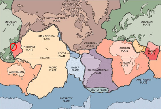
Maps: Your map is colourful and clearly shows where your disaster occured. However there are no arrows showing direction of plate movement.
Suggestion: Include some arrows into your map, and maybe add an explanation relating to your map.
Description of Disaster: Your explanation clealy explains what happened as a result of th disaster. It informs the reader well, and is easy to understand.
Suggestion: Maybe you could, add some more informaion about the actual eruption, rather than just the aftermath.
Explanaton of Plate boundry Near Disaster: There is no clear explanation of the plate boundries near where the disaster occured.
Suggestions: Maybe include a clearer section related to this heading, or maybe make its location a bit clearer by using maybe an image or subheading.
Overall Impression: The use of images are great, they make it more exciting and explain things that words cant. You’ve also added information about how turist attractions have benefited form the eruption, which was good use of intersesting facts.
Suggestions: Perhaps include some subheadings to make thigns easier to locate and more appealing to the eye.
Over all greaat job 🙂
8/10
What plate tectonics were involved?
What is the current state of the volcanoe?
Chile Earthquake 1960
Posted by 9sc19sc5 on August 22, 2011 at 10:56 am
The Philippine plate slid underneath the Eurasian plate, pushing up magma.
At the moment, the volcano is now home to a huge sulphur filled lake, which is a great tourist attraction.
Thanks for the feedback.
Posted by 9sc19sc5 on August 16, 2011 at 8:08 am
MAP: the map is quite detailed which is good since it shows all of the continents and plates clearly. The only thing that would improve this map is if you could make the location of the volcano stand out more by making the circle a different colour that would stand out and also by labelling that the circle is the location of the volcano.
DESCRIPTION OF DISASTER: the description outlines all of the main points that are supposed to be included and goes into detail with most of them. An idea that may improve your page is to further explain what the richter scale is and to include a comparison between a metric tonne and another measurement.
EXPLANATION OF PLATE BOUNDARY NEAR THE DISASTER: There is no explanation of the plate boundary near the disaster. A suggestion would be to include it.
OVERALL IMPRESSION: on the points that you answered the information is detailed and informing and straight to the point. The images are clear and of good quality, which further supports your information, however there are a few spelling and grammatical errors. Overall, an impressive page.
Rating: 8/10
Questions:
What was the status of the volcano before the eruption? i.e was it dormant?
What occurred at the plate boundary during the eruption?
Posted by 9sc19sc5 on August 22, 2011 at 10:57 am
It was dormant before the eruption, but pressure had been building for quite some time underneath the volcano.
During the eruption itself, the plates slid further and pushed up gas, causing a huge explosion.
Thanks for the feedback.
Posted by 9sc19sc5 on August 16, 2011 at 8:09 am
By the way that last review was from Steph, Annalisee and caitlin (the Nevada del Ruiz group)